The hill today, and the road and the beach below it a century ago, from the Instituto Moreira Salles collection.
Today1902 to the 1940s
Wilfredor, CC0, via Wikimedia Commons
Today
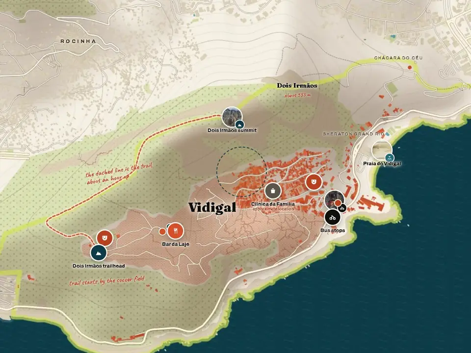
Vidigal today
Evenings at the top of the hill, the main road, the stalls and the view. These recent photos were released into the public domain by their photographer, Wilfredor, on Wikimedia Commons.
The houses of Vidigal lit up at night below the Dois IrmãosWilfredor, CC0, via Wikimedia CommonsA crowd on a terrace strung with lights at night in VidigalWilfredor, CC0, via Wikimedia CommonsThe street entrance to Mirante do Arvrão at night, with parked motorbikesWilfredor, CC0, via Wikimedia CommonsA street in Vidigal with market stalls, a motorbike and people walkingWilfredor, CC0, via Wikimedia CommonsA vendor at a stall with a Made in Vidigal sign and caps for saleWilfredor, CC0, via Wikimedia CommonsA man on a red motorbike on a street in VidigalWilfredor, CC0, via Wikimedia CommonsA building with a lit terrace and string lights at night in VidigalWilfredor, CC0, via Wikimedia CommonsPeople at tables on a restaurant terrace overlooking Vidigal at nightWilfredor, CC0, via Wikimedia CommonsLeblon, Ipanema and the lagoon seen from the top of Morro Dois IrmãosWilfredor, CC0, via Wikimedia Commons
Today
The hill from above and from the sea
Vidigal from the air, with Leblon and Ipanema beaches behindDois Irmãos above Avenida Niemeyer and the rocks at the end of LeblonSão Conrado beach between Pedra da Gávea and the Dois IrmãosA man on a rooftop looking out over Leblon and Ipanema
Then and now
The same view, a century apart
Before Leblon was built: the open plain seen from Morro do Vidigal. Instituto Moreira Salles collection, public domain
Leblon, Ipanema and the lagoon from the top of the Dois Irmãos today. Wilfredor, CC0, via Wikimedia Commons
Then
Avenida Niemeyer and Praia do Vidigal, 1902 to the 1940s
Avenida Niemeyer, the road along the sea at the foot of Vidigal, opened on 20 October 1916 and is named after Conrado Jacob Niemeyer, who paid for it. Between 1933 and 1954 it was part of the Circuito da Gávea street race around Morro Dois Irmãos. The houses of today's Vidigal went up from the 1940s.
The open plain of Leblon and Ipanema seen from Morro do Vidigal, before the neighborhood was builtInstituto Moreira Salles collection, public domainHouses on Avenida Niemeyer under the Dois Irmãos, between about 1916 and 1923Instituto Moreira Salles collection, public domainA race car on Avenida Niemeyer in the 1940sInstituto Moreira Salles collection, public domainPraia do Vidigal, between about 1928 and 1938Instituto Moreira Salles collection, public domainTwo women walking along the road by the sea under palm trees, early 1900sInstituto Moreira Salles collection, public domainAn early car on the cliff road of Avenida NiemeyerInstituto Moreira Salles collection, public domainAvenida Niemeyer along the sea with palm trees and Pedra da Gávea, about 1915 to 1925Instituto Moreira Salles collection, public domainAvenida Niemeyer and Pedra da Gávea behind a palm treeInstituto Moreira Salles collection, public domainAvenida Niemeyer winding along the rocks, seen from aboveInstituto Moreira Salles collection, public domainThe Vidigal shore and rocks, between about 1907 and 1915, in an early colour processInstituto Moreira Salles collection, public domainDusk on Avenida Niemeyer, with the mountains in silhouetteInstituto Moreira Salles collection, public domain
History
A short history
Instituto Moreira Salles collection, public domain
Vidigal is named after Major Miguel Nunes Vidigal, a 19th-century commander of Rio's military police, who received land at the foot of Morro Dois Irmãos from the Benedictine monks in 1820.
The first houses of the community went up in the 1940s, on the slope above Avenida Niemeyer. Growth was slow until the early 1960s and faster afterwards. In 1977, when houses were marked for removal, the residents' association won a suspension with the help of a state deputy, and the community stayed.